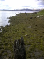
The harbour is located on the east bank of the mouth of the Black Devon. Two clusters of wooden piles are still visible in the muddy bank. The tallest piles measure c 4m high. The wood is in a severely rotten condition. The 1st ed OS map shows the Clackmannan pier and a tramway leading to it along the Black Devon. The tramway survives as a linear bank.
The bed and sides of the river has been lined with squared fairly regular stone at this point for approx 30-40feet.
This was to allow ships to load at all times of the tide,so that they would not be get stuck in the mud and be swamped when the tide came in. The condition of the stone lining. Fair.
2013 Clackmannan Pier:
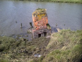
The remains of some substantial dressed timbers and wrought iron ties remain to show that the pier structures existed.
Indicated on the 1863 OS survey, about 60m back from the presumed end of the pier there appears to have been a small building. A brick chimney stack remains.
Location
289827.00
690361.00
27700
56.0932961
-3.7724097
Submitted photographs
Image
Date
Caption
User
27/04/2013
Brick chimney
phudsoni
27/04/2013
Clackmannan Harbour. Pile remains
phudsoni
Submitted updates
Update id
Date
User
2162
08/06/2015
DavidNewman
Tidal state
Mid
Site located?
Yes
Proximity to coast edge
Coast edge
Coastally eroding?
not eroding
Threats
none
Visibility above ground
Limited visibility (partial remains)
Visibility in section
Limited visibility in section
Access
accessible - difficult terrain
Local knowledge
is not locally known
Description
A tidal island c. 25x20m which is enclosed around its edge by a rubble wall. The wall is best preserved near the NW and SE corners. At its S end is a tidal peninsula c. 10m wide which connects it to Liernish, and the island walls extend along the shoreline both sides. Around halfway down the W facing shore at NF 87035 59015 lies a boulder revetted platform at the HWM which is probably a boat landing place. A few m SE of the island centre lies a pile of stones buried in heather.
None
Comments
These structures are presumably related to the settlement remains c. 30m to the south.
2083
24/05/2015
training1
Site located?
Unsure
Proximity to coast edge
>50m
Coastally eroding?
not eroding
Threats
none
Visibility above ground
Highly visible (substantial remains)
Visibility in section
Not visible
Access
accessible on foot (no footpath)
Local knowledge
is not locally known
Description
(i) A prehistoric house is located some 15m up slope from the house at LN29. It is aligned N-S and has an entrance which faces SSW. The site occupies a small level terrace on a rocky hillside. It is very well preserved, is largely covered with peat and does not appear to have been unduly disturbed since its abandonment. It measures 10m by 7m and is irregularly sub-oval in plan. The retaining bank is composed of earth and stone; the interior face is revetted with coursed stone and orthostats. The entrance area is more pronounced than at house LN29; the enclosing bank narrows at this point to form a short passage. Protruding stones to the exterior of the entrance suggest that there may be a porch or courtyard; but it is difficult to be certain of this since the area is obscured by peat. The interior is divided into five alcoves by means of piers which project from the inner wall face. Only the tops of these piers are now visible above the peat. (ii) To the S side of the house, discontinuous lines of stones appear to define a field system comprising two or more sub-circular or oval areas. The largest of these measures 20m by 25m. Further lengths of walling run off up slope and down slope but are quickly obscured by the peat. This site is of high archaeological potential and requires further survey.
24 May 2015
As described
remove from priorities, not on coast edge
Comments
Probably the site described but not absolutely certain, location quite far removed from original reference
2065
22/05/2015
training1
Tidal state
Mid
Site located?
Yes
Coastally eroding?
active sea erosion; has eroded in the past
Visibility above ground
Not visible
Visibility in section
Limited visibility in section
Access
accessible on foot (no footpath)
Local knowledge
don't know
Description
A quantity of artefacts of Iron Age type were found in a midden deposit at West Ayre. These included four bone weaving combs, pottery, bone implements as well as bone and shell. A comparison of the previous records would appear to indicate that this midden may have been associated with structures and that it has been eroding for almost a century. In 1980 further traces of midden deposits were found. The site was not located during this survey; this may have been due to the presence of dense vegetation along the shore edge.
22 May 2015:
A rectangular building and midden deposit visible in the eroding coast edge in a section visible to a height of 0.5m above a storm beach. Two walls of the building and a possible paved stone floor are visible. The northern wall is constructed of a large edge set stone with three courses visible on the inner face. The building is approximately 6m long, and the interior is filled with midden and cobbles. One large stone forms the only visible remains of the southern wall. The midden contains fishbone and shell, one piece of pottery was noted. This midden deposit continues to the north beyond the building, where a lens of mussel shell is visible. Further round the bay to the north, deep cultivation soil is visible in the exposed section. This site is on the coast edge in a high energy environment, a steeply-sloping storm beach has formed below this eroding face. There are large erosion scars on the coast edge to the north of the bay, while dumped material to the south of the site forms an ad hoc coastal defence for a modern track.
The site would benefit from a small project to clean and record the features visible in the section and sample for dating.
Section cleaned and recorded by Archaeology Shetland in 2015.
The coast edge is vulnerable and significant change has occurred since the CZAS survey and the site is actively eroding. Reassign to priority 1.
1998
04/05/2015
training1
Tidal state
Mid
Site located?
Yes
Proximity to coast edge
Intertidal
Coastally eroding?
active sea erosion; has eroded in the past
Threats
tipping
Visibility above ground
Limited visibility (partial remains)
Visibility in section
Clearly visible in section
Access
vehicular access
Description
The building has been sectioned by coastal erosion, and it appears from the surviving stretches of the outer walls that more than half of the broch has been destroyed.
Structural remains may continue to the north, but modern dumping obscures this area of coast.
Assign priority 1 score.
Comments
This is a high-priority site. It is both important and vulnerable to further damage and destruction by coastal erosion, and together with the associated settlement (12903) to the south should be assigned priority 1.
1932
27/02/2015
jamesmccomas
Tidal state
Low
Site located?
Yes
Proximity to coast edge
11-50m
Coastally eroding?
active sea erosion
Threats
structural damage/decay
Visibility above ground
Limited visibility (partial remains)
Visibility in section
Limited visibility in section
Access
accessible on foot (no footpath)
Local knowledge
don't know
Description
line of posts running east west along beach approx 9 metres long and 0.5 m high. possible sea defences. approx 15 metres to the east a few more posts can be seen, apparently part of the same line
None
1926
10/02/2015
smoricebroom
Tidal state
Low
Site located?
Yes
Proximity to coast edge
>50m
Coastally eroding?
not eroding
Threats
stock erosion; animal burrows
Visibility above ground
Highly visible (substantial remains)
Visibility in section
Not visible
Access
accessible - difficult terrain; accessible on foot (no footpath)
Local knowledge
don't know
Description
SMR 7008. post mdieval field system, seen as lazy beds today.
to map out entire area, as very large area which seem to correlate.
1905
28/01/2015
DavidNewman
Tidal state
Mid
Site located?
Yes
Coastally eroding?
active sea erosion
Visibility above ground
Highly visible (substantial remains)
Visibility in section
Not visible
Access
accessible on foot (no footpath)
Local knowledge
is well known
Description
Remains of what appears to be a wheelhouse, exposed by coastal erosion, are situated at A' Ceardach Ruadh (the Red Smiddy) on the west side of Baleshare Island where the machair ends in a sandy cliff above the beach. Cists and skeletal material have been recovered form this site. Coastal erosion had removed 7-8m of the beach front in the 1990s. No wheelhouse was visible at this location though there was some stone lying on the beach. A piece of human skull and a sherd of pottery were collected from the beach at this point. The midden identified at site 637, continues along next to this site.
22/09/2014
ShoreUPDATE:
A 2-3m thickness of midden material comprising peat ash with frequent marine shell, bone and pot exposed along 50-60m of eroding dune face. A small amount of stone, just appearing appears to be laid horizontally. No sign of other stone structures yet. They may survive in the mound of which the midden forms the seaward side.
This is almost certainly the beginnings of the erosion of a further wheelhouse; part of the settlement of which wheelhouse 9609 c. 200m to the north is part.
January 2015
Images sent in by David Newman from December 2014 and January 2015 show that erosion has continued during the winter storms of 2014-15. As well as removing the sand from the adjoining beach, the dune face has been scoured exposing the midden deposits already revealed, including much redder coloured midden material to the south. The stones recording in the September 2014 update are still visible in the January images. Further south another long section of midden around 1m high has been revealed extending the site almost to the trackway evident in the satellite image. To the north a new stone structure has been revealed at the beach level around 10m north of the existing stone features.
None
Comments
Erosion has continued during the winter storms of 2014-15. As well as removing the sand from the adjoining beach, the sectional face of the site has been scoured revealing more shell and bone deposits on the already revealed faces, and much redder coloured midden material to the south. Further south another long section of midden around 1m high has been revealed extending the site almost to the trackway evident in the satellite image. To the north a new stone structure has been revealed at the beach level around 10m north of the existing stone features.
1884
09/12/2014
training1
Tidal state
Low
Site located?
Yes
Proximity to coast edge
Coast edge
Coastally eroding?
has eroded in the past
Visibility above ground
Limited visibility (partial remains)
Visibility in section
Limited visibility in section
Access
accessible on foot (no footpath)
Local knowledge
don't know
Description
(i) A noost, 6m long by 2m wide, is cut into grassy banks at the tip of a small headland. It has revetted drystone walls, which stand up to 1m high, and a pointed end. The interior is overgrown. (ii) The remains of a rectangular structure survive to a height of 0.75m. It measures 8m long by 2.5m wide and adjoins a boundary wall which runs parallel to the coast edge. A single doorway leads into the interior which contains two slabs which project from the back wall and may have formed a bench or cupboard. The interior is very overgrown.
ShoreUPDATE 19/04/2013
As described
None
Comments
Extreme wet and windy weather during site visit prevented photography.
955
27/04/2013
phudsoni
Tidal state
Mid
Site located?
Yes
Proximity to coast edge
Coast edge
Coastally eroding?
not eroding
Threats
structural damage/decay; water erosion (e.g. stream, etc)
Visibility above ground
Limited visibility (partial remains)
Visibility in section
Not visible
Access
accessible on foot (no footpath)
Local knowledge
is not locally known
Description
Clackmannan Pier:
The remains of some substantial dressed timbers and wrought iron ties remain to show that the pier structures existed.
Indicated on the 1863 OS survey, about 60m back from the presumed end of the pier there appears to have been a small building. A brick chimney stack remains.
Take measurements to locate the wooden pile remains.
Comments
Original CZAS record: "The harbour is located on the east bank of the mouth of the Black Devon. Two clusters of wooden piles are still visible in the muddy bank. The tallest piles measure c 4m high. The wood is in a severely rotten condition. The 1st ed OS map shows the Clackmannan pier and a tramway leading to it along the Black Devon. The tramway survives as a linear bank.”
Site recorded by GUARD during the Coastal Assessment Survey for Historic Scotland,” (“The Firth of Forth from Dunbar to the Coast of Fife' 24 February 1996.")
Reference 2: “Clackmannan Pow, Clackmannanshire. NS 895903-898904
In 1841 there existed 'pretty extensive piers at the mouth of the Black Devon',1 a muddy tidal creek opening into the Forth, and though the remains are of little archaeological interest the site deserves to be noted for its place in a by-gone pattern of industry. Today the piers are represented only by four groups of decayed piling on the left bank, two close to the entrance and two on the upper part of the lowest meander. Other stakes are probably remains of revetment. The dyke that protects the reclaimed ground to the SE. has a road on top of it, and its lower end is covered with mounds of what is probably dredged material; these recall the loan of dredging plant by the Alloa Harbour Trustees to the Clackmannan Coal Company in 1887.2 (Cf. Kennetpans.)”
(From Graham: Archaeological Notes On Some Harbours In Eastern Scotland 1968-9)